Difference between revisions of "S-57 Java Suite"
(→Structure) |
|||
| (One intermediate revision by the same user not shown) | |||
| Line 16: | Line 16: | ||
Code: http://svn.openstreetmap.org/applications/editors/josm/plugins/seachart/ | Code: http://svn.openstreetmap.org/applications/editors/josm/plugins/seachart/ | ||
| + | |||
| + | [[category:Projects]] | ||
| + | |||
| + | == Component Applications == | ||
| + | === SeaChart === | ||
| + | This is the primary application of the suite. It provides an imagery layer plugin for JOSM. It renders a complete chart as would be generated by the base layer and seamark layers of the renderer. | ||
| + | === Jrender === | ||
| + | This is the seamark layer renderer. It generates PNG tiles for the online map. | ||
| + | === Jicons === | ||
| + | This renders PNG or SVG icons of point objects for use in third-party charting applications. Its input is an OSM-style XML file using the seamark tagging scheme, plus additional tags to specify the scale, alignment and format of the icons. | ||
| + | === Jbasemap === | ||
| + | This generates SVG images of natural and cultural map features, rendered in the INT-1 style. Its input is a bounded OSM file. | ||
| + | === Jplotter === | ||
| + | A real-time chart plotter. | ||
| + | === Js57toosm === | ||
| + | Converts S-57 ENC files to OSM files | ||
| + | === Josmtos57 === | ||
| + | Converts OSM files to S-57 ENC files | ||
Latest revision as of 17:08, 10 January 2016
This suite of applications uses a common class library that provide the means to convert data between OSM and S-57 formats.
Contents
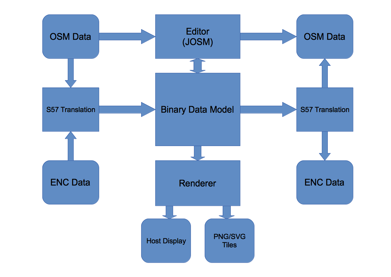
Structure
In this illustration, the top line (OSM input, Editor, OSM output) represents JOSM together with the "seachartedit" plugin.
The S57 translation blocks convert OSM data or S57 ENC data to/from an internal binary model that is compatible with both OSM structures and the S57 chain-node model used by ENC.
The binary data model provides the inputs to various renderers, host displays & file outputs.
The renderer will provide the core engine for applications besides JOSM, principally our map tile generator, but also could be used in other applications, such as chart plotters.
The renderer's output is sent to the host display (an imagery layer, "seachart", in JOSM or a chart plotter screen). The rendering applications can output both PNG and SVG tiles.
Code: http://svn.openstreetmap.org/applications/editors/josm/plugins/seachart/
Component Applications
SeaChart
This is the primary application of the suite. It provides an imagery layer plugin for JOSM. It renders a complete chart as would be generated by the base layer and seamark layers of the renderer.
Jrender
This is the seamark layer renderer. It generates PNG tiles for the online map.
Jicons
This renders PNG or SVG icons of point objects for use in third-party charting applications. Its input is an OSM-style XML file using the seamark tagging scheme, plus additional tags to specify the scale, alignment and format of the icons.
Jbasemap
This generates SVG images of natural and cultural map features, rendered in the INT-1 style. Its input is a bounded OSM file.
Jplotter
A real-time chart plotter.
Js57toosm
Converts S-57 ENC files to OSM files
Josmtos57
Converts OSM files to S-57 ENC files
